Volunteer opportunity details from Grampus Heritage and Training:
We would like to invite you to work off those mince pies by joining us for some exciting archaeological fieldwork at Drumburgh and on Burgh and Easton Marsh. This fieldwork follows on from our geophysical survey at Drumburgh Castle Farm and our excavations there in October last year. With funding from Defra, through the Solway Coast National Landscape’s Farming in Protected Landscapes programme, we have another opportunity to work with local volunteers to increase our understanding of this fascinating historic landscape. The fieldwork involves both geophysical survey and excavation as described below:
Geophysical Survey on Burgh and Easton Marsh
Mon-Fri: 19th to 23rd Jan
Mon-Fri: 26th to 30th Jan
Mon-Fri: 2nd to 6th Feb
4 Volunteers per day
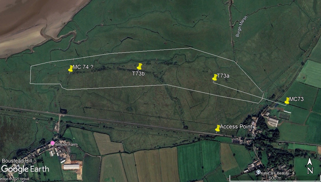
In October 2025 we discovered a well-preserved section of Hadrian’s Wall heading towards Easton Marsh at Drumburgh. The Wall at this location was clearly descending and continuing to fall in elevation to the east over a fossil marsh edge. One of the aims of our research in this area was to ascertain whether Hadrian’s Wall continued across the marsh to the east or turned to the south to follow the higher ground. The evidence we found suggests that the wall does continue across the marsh as, if it had turned to the south, it would surely have done so on higher ground. Although we can conclude that this is now the most likely scenario, it is not conclusive.
In 2004 a geophysical survey at Dykesfield, at the far eastern edge of the marsh, was successful in locating Milecastle 73 (Biggins, Hall & Taylor. 2004). Although no excavation was carried out at Dykesfield, the Milecastle and course of the wall are clear in the results. At Dykesfield, as at Drumburgh, we have evidence for Hadrian’s Wall being built right up to the marsh edge but no survey has ever been carried out on the marsh itself… until now. In a classic ‘pincer movement’ we will conduct a geophysical survey on Burgh and Easton Marsh to search for evidence of Hadrian’s Wall.
The two attached Google Earth images show the areas in which we will work. In the west (Drumburgh / Easton Marsh) we will undertake a geophysical survey to the east of the canal and embankment. The straight line in the attached image shows the projected line of the wall from our October excavations. In the east (Dykesfield / Burgh Marsh) we will undertake a geophysical survey covering the projected line of the wall from the 2004 survey. Burgh Marsh will be the main focus of our survey activity as the land area is larger. Here, we will work from east to west in the hope that we can detect evidence for the wall and see how this may relate to the more visible earthworks to the west. We will not have time to cover all of the areas highlighted but will seek to identify and follow the course of the wall within these areas.
Excavation at The grange, Drumburgh
2nd – 14th Feb (excluding Sunday 8th Feb)
5 Volunteers per day
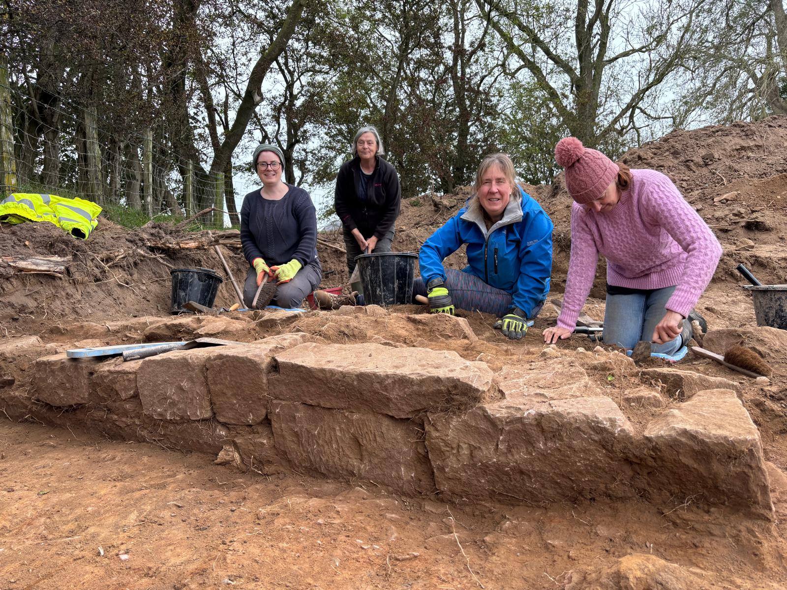
During our October excavations we opened a trench behind The Grange at Drumburgh searching for evidence of the fort of Congavata. The results of this excavation are intriguing. We found evidence of two large ditches but only a small amount of Roman material, none of which came from the lower ditch fills. We await the carbon dating results to help us determine the date of these features but it is clear that we have much more to learn about the archaeology in this area. The geophysical survey revealed an apparent circular anomaly to the west of the scheduled area and this will be our excavation target in February (see attached ‘dcf-b trench location’).
The first week of the excavation overlaps with the final week of the
geophysical survey.
Volunteering (Geophysics and Excavation)
Working hours for volunteers are from 09:30 – 16:00 each day. Days may be
cancelled or cut-short in the event of extreme weather.
Please bring your own lunch, warm waterproof clothing and wear sturdy boots
for excavation. Tools, equipment and training will be provided and no
previous experience is necessary to participate.
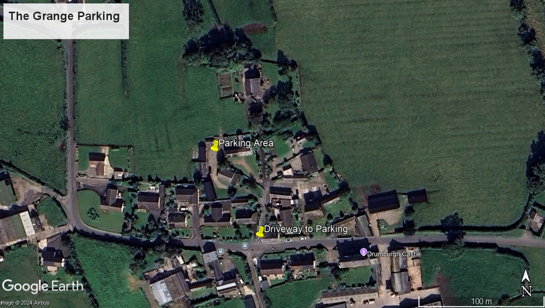
Google Earth images are attached to show the location of Drumburgh and the
parking area at: The Grange, Drumburgh, CA7 5DW. To access the Grange, enter
the village of Drumburgh and take the turning opposite the signposted turn
to the RSPB reserve. Follow the track around to the left to enter the
parking area.
Toilet facilities and a covered area for lunch break are available at the
Grange. We are extremely grateful to Sarah Hodgson and family for making
these facilities available. Please note that toilet facilities are not
available on the marsh during survey but we can return to use the facilities
at the Grange as required.
Parking Location what3words: crumbles.quicker.even
We aim to work with 5 volunteers per day throughout the excavation and 4
volunteers per day on the geophysical survey.
Please email 𝐞𝐦𝐦𝐚𝐠𝐫𝐚𝐦𝐩𝐮𝐬𝐡𝐞𝐫𝐢𝐭𝐚𝐠𝐞@𝐠𝐦𝐚𝐢𝐥.𝐜𝐨𝐦 to register your interest. Emma will
compile the volunteer list and allocate spaces.